Hear from Gemma Coxon, hydrologist at the University of Bristol, on the collaborative effort to make a new version of CAMELS-GB even more accessible and comprehensive.
What is the dataset and who is the team behind it?
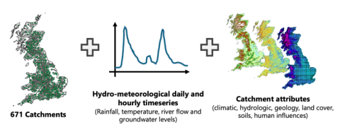
CAMELS-GB v2 is the latest version of CAMELS-GB; a large-sample, open-access, catchment dataset containing hydrometeorological time series and landscape attributes for 671 catchments in Great Britain. Led by the University of Bristol, the compilation of the dataset has been a huge collaborative effort spanning inputs from researchers and public bodies, including:

What is new about the data?
Since being produced in 2020, CAMELS-GB has been widely adopted in academia and industry to:
Define knowledge gaps in our understanding of Great Britain hydrology
Accelerate the emergence of machine learning approaches for hydrology
Shed new light on human impacts on river flows
CAMELS-GB v2 builds on CAMELS-GB by (1) extending the daily hydro-meteorological timeseries from 1970- 2022 including meteorological timeseries from new observed climate datasets, (2) providing new hourly precipitation, river flows and level timeseries, (3) providing new groundwater level timeseries and attributes for 55 groundwater wells, and (4) providing new catchment attributes characterising changing land cover, peak flows and human influences.
How can the dataset be used and where can you access it?
The CAMELS-GB v2 dataset is freely available to the hydrological community under an Open Governmental License and is designed to be an easily accessible dataset to use in a wide range of environmental data and modelling analyses. It collates billions of observations from across Great Britain at hourly to monthly timescales, including quality-controlled daily river flows, catchment boundaries, and catchment characteristics from the UK National River Flow Archive. It can be accessed through the EIDC.
A research paper describing the dataset will be made available from Earth System Science Data shortly.
What were the key learnings from collating the dataset?
The importance of collaboration to ensure the dataset is as innovative and useful as possible for the community. The UK Floods and Droughts Research Infrastructure played a key role in supporting this community effort by providing key datasets, facilitating relationships between key partners and enabling upload to the Environmental Information Data Centre.
The other key learning is to have patience! The first CAMELS dataset took 7 years in total to produce, version 2 has taken significantly less time (3 years) but is still a major undertaking.
Are there any future plans with the data?
The dataset is currently being used to benchmark hydrological models as part of the UK Hydro-MIP and for operational flood hydrology as part of the Flood Hydrology Improvement Plan. We also plan to make use of the dataset for training purposes within FDRI, as part of our summer schools, and provide cloud-optimised versions for machine learning.
Get involved
Are you planning to use, or already using, CAMELS-GBv2? We want to hear from you! We’re on the lookout for case studies of how FDRI-enabled data is supporting research and industry. We’re keen to share success stories and learnings with the community, as well as ensure we prioritise the right data resources for future updates. Contact Anna Klaptocz to share your experience and get a chance to feature in our newsletter.