The FDRI digital infrastructure offers an opportunity to transform the way the hydrological research community access and work with monitoring data.

Image
digital

Near real-time data from FDRI research monitoring

FDRI will deliver openly accessible, near real-time data from all catchment and mobile monitoring infrastructure. This will use cloud-based “Internet of Things” approaches to capture sensor data and set a gold standard for research monitoring data provision. Data will be enhanced with automated quality control and filling in gaps using methods like machine learning.


Comprehensive sensor metadata, including uncertainty information, will be provided and datasets will have consistent formats to support integration with other data, and new research.

Image
Person viewing data on a laptop

Improving access to existing UK-wide hydrological data

FDRI’s new data management systems will improve access to existing UK-wide hydrological data at sub-hourly resolutions. Rainfall, river levels and flows, and meteorological variables from sensors operated by UK agencies, research groups, water companies and citizen science groups will be incorporated within its data management tools.  


This will benefit research users through enhanced quality control and consistent data access. This work will contribute to the UK Flood Hydrology Roadmap.  


FDRI will identify opportunities to improve access to datasets such as rain radar, Earth Observation, LiDAR and other sources to facilitate new research.

Image
Computer chips

Enabling new approaches to hydrological research

FDRI will provide new web-based platforms to support researchers to access and analyse data. It will help researchers make use of NERC large data storage and computing power at JASMIN for data analysis. It will make use of NERC DataLabs – a web-based notebook environment running on the JASMIN research cloud – enabling users to find, explore and analyse data.


FDRI platforms will allow users to share and publish research code and data outputs, and example workflows will be provided to encourage and support an Open Science approach.

Image
Abstract 'data' graphic

Supporting innovation

FDRI digital platforms will support innovation in hydrological monitoring and analysis of hydrological data. Enabling simple transmission and management of data from FDRI sites, providing instrumentation developers use of Internet of Things approaches for streaming and real time visualisation of data. This will advance the uptake of sensor data standards within hydrological research.  


We will develop advanced data management and processing systems for new hydrological monitoring approaches such as drone-captured video for river flow monitoring. The new data from FDRI and wider UK monitoring will provide significant opportunities for innovation both within hydrological research and wider research communities, for example opening up data to researchers in fields of AI, health, and engineering.

Building the digital hydrological research community

FDRI will build and engage with a community of researchers through stakeholder events, conferences, training courses, and hackathons. Seeking input from the existing hydrological research community, both within and outside academia, as well as from wider domains and specialisms. And we will encourage participation from the next generation of researchers to help build the community for the future.  

We will use this community to understand requirements for the digital infrastructure and to help us prioritise the functionality being developed. We will help to build and foster a community to support open-source hydrological research tools and provide guidance in best practice for research software development to allow tools to be integrated within the FDRI infrastructure. We will provide training resources to support ongoing uptake of the FDRI platforms.

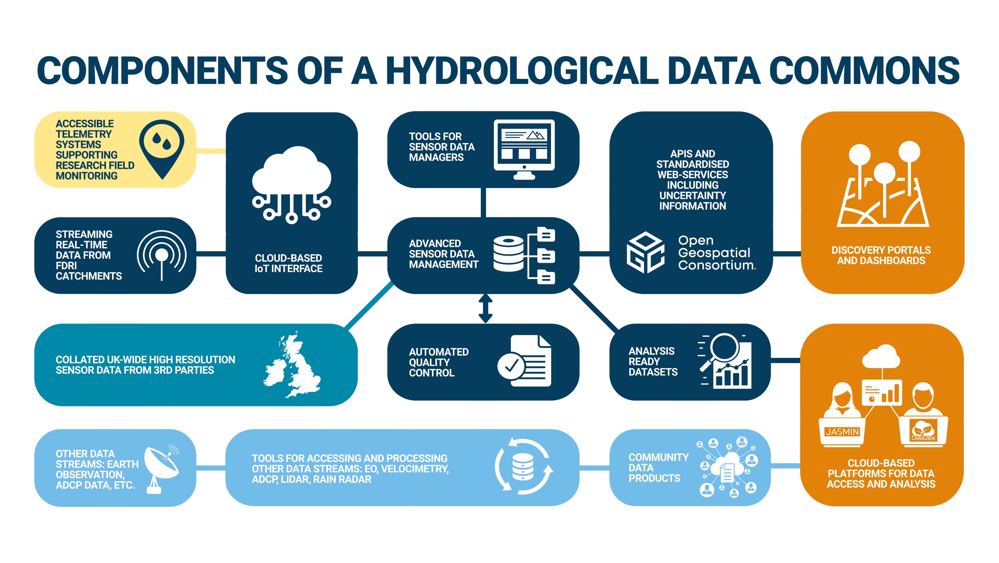
Components of a hydrological data commons

Text description of this graphic:

The figure title is 'Components of a hydrological data commons'. The figure is a series of boxes, as follows:

  • 'Accessible telemetry systems supporting research field monitoring', and...
  • 'Streaming real-time data from FDRI catchments', both connect to...
  • 'Cloud-based Internet of Things interface', which connects to...
  • 'Advanced sensor data management'. This connects to five boxes:
    1. 'Tools for sensor data managers'
    2. 'Collated UK-wide high resolution sensor data from 3rd parties'
    3. 'Automated quality control'
    4. 'Analysis-ready datasets'
    5. 'APIs and standardised web services including uncertainty information'
  • This last box (5) connects to 'discovery portals and dashboards'
  • The 'Analysis-ready datasets' box connects to...
  • 'Cloud-based platforms for data access and analysis'
  • Three further boxes are connected as follows:
    1. 'Other data streams: earth observation, ADCP data, etc.' connects to...
    2. 'Tools for accessing and processing other data streams: EO, velocimetry, ADCP, LIDAR, rain radar'. This connects to...
    3. 'Community data products', which also connects to the previously described 'Cloud-based platforms' box.